This flight will be the last for this version of my APRS rocket tracker. It appears that the transmitted RF interfered with the operation of both altimeters.
Both altimeters have unusual features in the recorded data with the AltAcc being effected the worst. The RDAS shows periodic blips in the pressure data and four of these match up very well with the transmitted GPS data that was received by a local digipeater:
KC5WSV-9>APT202,RELAY,WIDE,qAS,K5YM:!3333.04N\09557.65W^038/028/A=007447
KC5WSV-9>APT202,RELAY,WIDE,qAS,K5YM:!3333.25N\09557.40W^043/026/A=006489 53 58
KC5WSV-9>APT202,RELAY,WIDE,qAS,K5YM:!3333.57N\09557.15W^036/019/A=005160 115 120
KC5WSV-9>APT202,RELAY,WIDE,qAS,K5YM:!3333.67N\09557.12W^329/007/A=004333 154 157
KC5WSV-9>APT202,RELAY,WIDE,qAS,K5YM:!3333.69N\09557.15W^263/009/A=004074 166 168
The added columns after the altitude are times determined by matching the APRS reported altitude with the GPS track data recorded by the Garmin Summit and the times for the blips in the RDAS data. While the times do not match precisely, they are close enough to constitute a smoking gun. Electromagnetic interference was the cause of the early ejection and the data glitches.
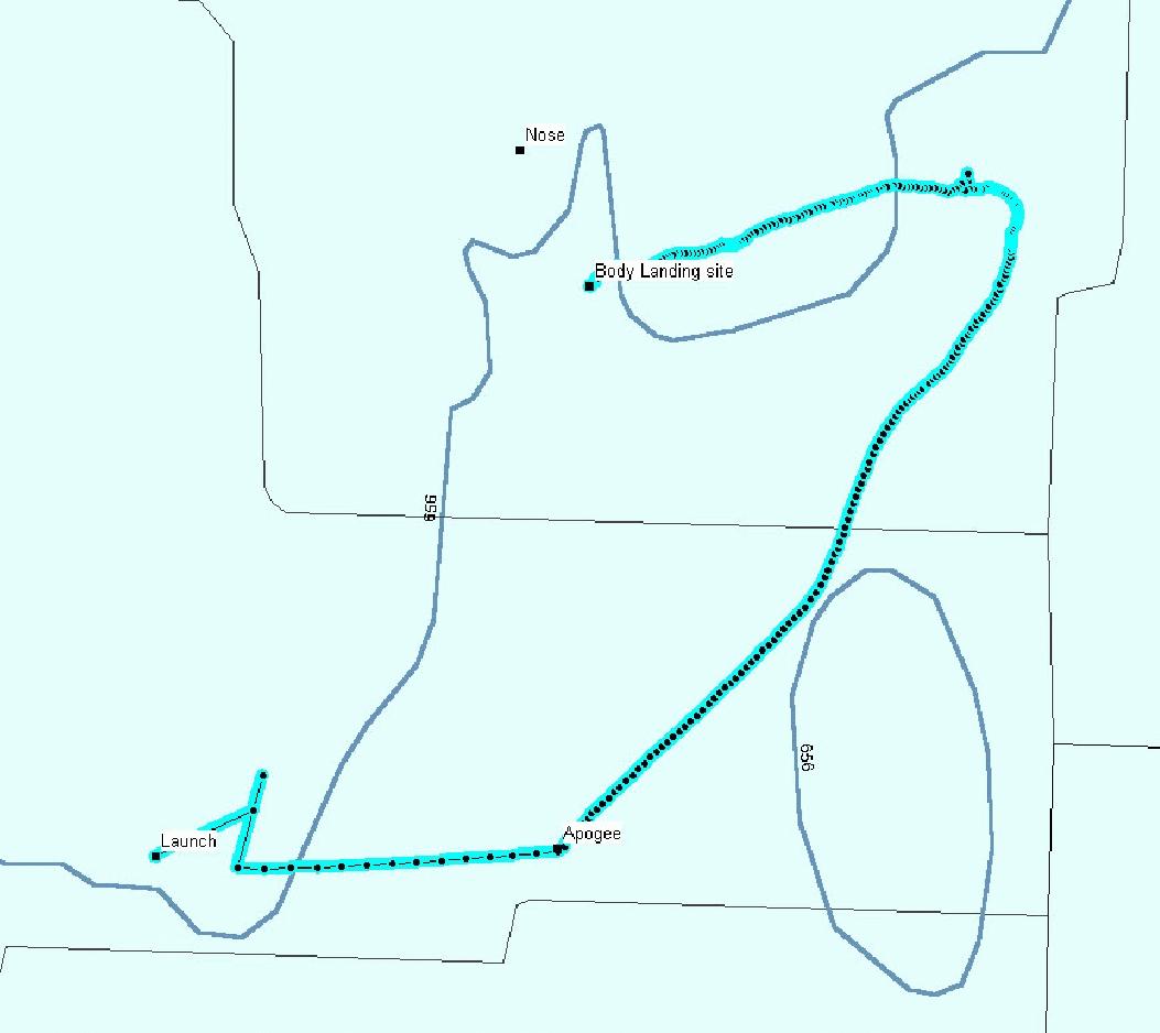
I plotted the track recorded by the Garmin GPS unit using the Mapsource software.
The first few positions after launch have large position errors which is typical for this unit. It then provides good positions for the rest of the flight with one exception. The ground level winds were from the east and the rocket weathercocked into it. Then at apogee it starts drifting to the northeast. The raw data shows that the wind speed at this altitude was around 30 knots. Around 4,000' the winds started to shift and the rocket made almost a 180 degree turn. You might have noticed that the 7,447' altitude reported over the APRS link is higher than any of the altitudes recorded by the Garmin internally. This is apparently due to the Garmin units reporting the GPS altitude over the NMEA serial link and recording its pressure sensor based altitude internally.
The nose recovers on a separate parachute so it was located some distance from the rest of the rocket. While I found the main part very easily, the nose proved to be a lot harder. The landing area was a mix of harvested (2' to 3' tall stubble) and unharvested (3' to 4' tall) milo (a.k.a. grain sorghum). This meant that you practically had to walk on top of something in order to see it. I spent some time walking around Saturday but never found the nose. I tried again Sunday morning and found the nose on the edge of an unharvested patch. It was in a harvested area so it was safe from the combine harvester that was working a field a mile or so away at the time.